Llactapata
Inca village, located at 2,840 meters above sea level at the confluence of the Cusichaca, Urubamba rivers in the mountain called Patallaqta, province of Urubamba, department of Cusco.These are Ica constructions with well-defined sectors, enclosures, platforms, squares, stairways, canals, etc. Highlight, especially the agricultural terraces and their drainage system. Llactapata del Camino Inca was an eminently agricultural town, it was probably the place where the products of the Valley were concentrated. It has constructions separated from the platforms that could be barns.
Warmi Wañusqa
(Quechua name) “woman who died” or “woman died”, is a mountain pass in the Cusco Region in Peru. It is located in the Urubamba Province, Machupicchu District. Warmi Wañusqa lies on the Inca Trail to Machu Pikchu, southwest of the archaeological site of Patallaqta. It is situated at a height of 4,200 masl.
Pakaymayu
Is a river in Peru located in the Cusco Region, Urubamba Province, Machupicchu District. It is a left tributary of the Willkanuta River. The Pakaymayu originates in the Willkapampa mountain range northeast of Sallqantay and north of P’allqay (Paljay) near the Warmi Wañusqa pass, the archaeological site of Runkuraqay and the Runkuraqay pass. Its direction is mainly to the northeast, almost parallel to the Kusichaka River east of it. The confluence with the Willkanuta River is west of the village of Pampa Q’awa (Pampacahua)
Runkuraqay
Is located at an altitude of 3,750 masl and overlooks the valley. Runkuraqay quechua name o Tambo was an Incan structure built for administrative and military purposes. Found along Incan roads, tambos typically carried supplies, served as lodging for itinerant state personnel, and were depositories of quipu-based accounting records. Different types of tambos existed; those that served to lodge the traveling Inca and his entourage (typically wives and state officials), and those that served as relay stations for the chasquis, who were state messengers who ran along state roads.
Puyupatamarca
This archaeological is one of the most beautiful sites in the Inca Trail and along the Inca Trail in the Urubamba Valley of Peru. Due to its altitude of roughly 3600 meters,[ it is known as “La Ciudad entre la Niebla” (“The City Above the Clouds”) and almost always with clouds. This ruin contains terraces, a serpentine vantage point, and an intricate series of ceremonial baths connected by water channels. Cloud level Town stands where the trail crosses from south to north of the long ridge leading to Machu Picchu. It is overlooked by flat-topped peaks whose Inca platforms were built for viewing a breathtaking panorama of snow peaks.
WiñayWayna
The hike to the ruins of WiñayWayna is like a hike through time itself. Something about it just feels eternal. The name means “forever young” in the native Andean tongue of Quechua—a name perfectly suited to such an ageless site. The ruins date to the mid-15th century, constructed during the days of the powerful Inca Empire. They are one of the stops along the Inca Trail, and the exact purpose of the site is tough to say. It may have been a spiritual or religious destination, or just a place for resting before arriving at the end of the 26-mile journey to MachuPicchu. The ruins consist of upper and lower collections of Inca architecture, connected by stone steps that are laid out in graceful curves. The upper structures have a unique, circular building, while below there is a collection of linear parapets with sharp peaks, jagged walls, and massive stone slabs with little space between them. The precarious staircase between the two levels hugs a long line of ancient fountains, often referred to as baths. What is remarkable about the site is how limited the Inca were in terms of the available construction tools. With nothing more than implements made from bronze or stone, the amount of human labor required for such a massive production is almost impossible to imagine.
Inti Punku
(Quechua inti: sun, punku: door “sun gate”) is an archaeological site in the Cusco Region of Peru that was once a fortress of the sacred city, Machu Picchu. It is now also the name of the final section of the Incan Trail between the Sun Gate complex and the city of Machu Picchu.
It is one of the most important archeological constructions around the Machu Picchu citade. Inti Punku was once the main entrance to Machu Picchu, in particular it was the primary approach from the then capital city of Cusco to the southeast. The gate was probably by Incan military. It is believed that Inti Punku was created not only for military purposes but also to show the loyalty to the Inti, the Sun god. It is located 2745 masl. southeast of Machu Picchu, the rising sun would pass through the Sun Gate each year on the summer solstice. It is a wide archaeological site with windows and gates that are held up by terraces. This is the first place that tourists can see the whole Machu Picchu sanctuary Huayna Picchu Mountain, Vilcabamba/Urubamba River, and Putukusi Mountain are all visible.
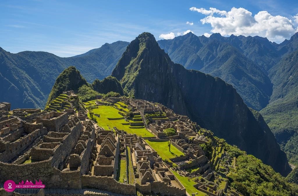
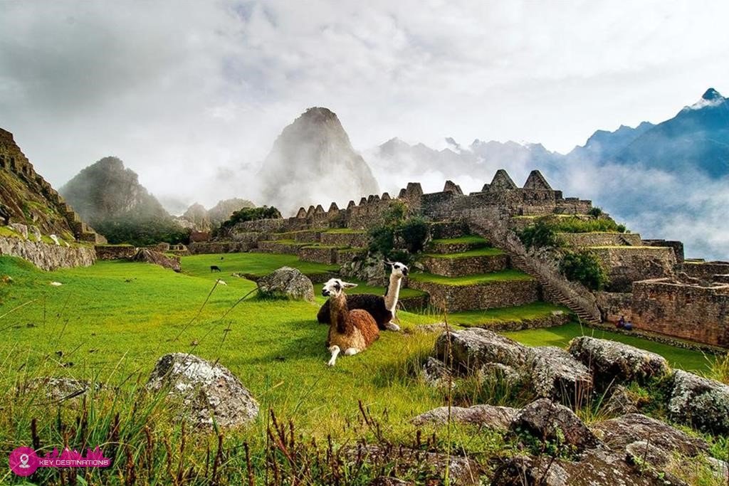
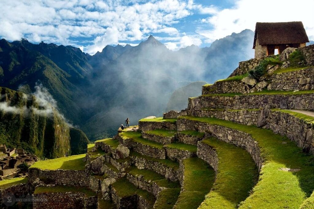
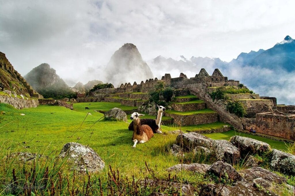
Machu Picchu
Machu Picchu took some 30 years to construct. Built during the reign of Inca Pachacutec (1438 – 1471), Due to limited historical information the true and original name of this epic Inca citadel is unknown. Machupicchu’s name derives from the mountain that lies to the south-west of the citadel, meaning “Old Mountain.” Machu Picchu citadel covers a vast area of approximately 9 hectares (22.3 acres), and is constructed on a mountain ridge high above the Sacred Valley.
Machu Picchu is split into two main sectors: the Agricultural Sector in the south and the Urban Sector in the north, of which both are roughly equal in size. Granite stone was the main building material used in the construction of Machu Picchu, which was obtained from onsite quarries and others within close proximity. The finest Inca construction techniques were reserved for the Royal Quarter; the best examples are found at the Sacred Square, the Temple of the Sun and the Temple of the Moon. This magic and epic Inca citadel is one of South America’s greatest archaeological sites. In 1981, Machu Picchu was declared a Peruvian Historical Sanctuary and later in 1983, it became a UNESCO World Heritage Site.
CD616KD
Alejandro Velasco Astete Airport, Cusco Peru (Google Map)
3 Hours Before Flight Time
Traveling to Cusco should not be underestimated remember that the Inca Empire is 3,400 meters (11,200 feet), therefore, we recommend consulting your doctor about altitude pills and vaccines you may need.
You can expect a really nice adventure which you absolutely will remember for a very long time. Machu Picchu is about 2500 meters (8200 feet) above sea level and the hike to there is just very unique and special. You will see several old Inca ruins on the way to there and eventually reach Macchu Picchu. Experience the hikes the Incas did at the time.
Reception at the airport and transfer to the hotel in Cusco, accomodation and coca tea as welcoming drink.
19 hrs. Briefing about Inca Trail and recomendations
Hotel night in Cusco
Cusco- KM. 82 –Wayllabamba (5 hrs. Approx) Transfer from hotel to km 82, via Chinchero. At this point we pass the control checks, meet with the camp team and start the walk along the Urubamba River until Llactapata ruins. We lunch along the way, then we continue until Wayllabamba (dinner). Amazing vegetation and lampscapes during the hiking.
Camp Night Wayllabamba
Wayllabamba – Pacaymayu (6 o 7 hrs. approx)
After breakfast at the camp, we start the hike to the highest point of the Inca Trail, from where we can observe different altitudinal floors and climates from the rain forest Yunca chimpa to the Mountain range of Warmiwañusca at 4250 m.s.n.m. After crossing this point we have lunch then we continue the trek towards Paqaymayu sector where we organized our second camp. Free afternoon around the beutiful lanscapes, dinner.
Camp night at Pacaymayu.
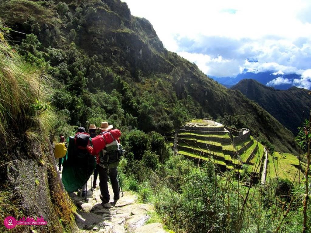
Pacaymayu – Wiñaywayna (6 hrs. approx)
After breafast in the camp we start walking for 50 mins to the second point at 3850 MASL passing through archaeological site of Runkurakay, from this point we descend towards the archaeological site of Sayacmarda (at this point we will observe how the geography changes its appearance, from dry and highland mountains to semi tropical green, jungle brow). Along the way we will see the archaeological site of Phuyupatamarca, where we enjoyed lunch. We continue to Wiñaywayna – visit to this archaeological site – break.
Last camp night at Wiñaywayna.
WIÑAYHUAYNA- MACHUPICCHU- CUSCO
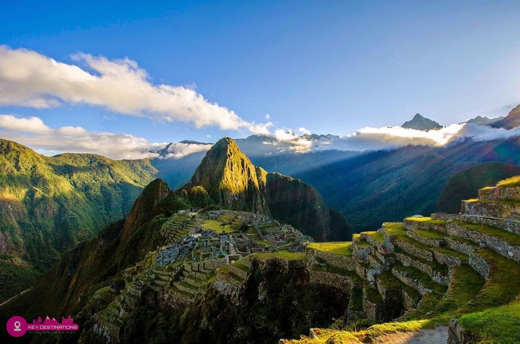
Early morning we start the walk after breakfast to the Inti Punku sector, where it will be possible to observe the sunrise and also we will appreciate the panorama view of Machupicchu Sanctuary. From this point we start the walking until the wonderful Machupicchu, guided visit in this amazing place, full of history, culture and energies- free time for resting and photos. In the afternoon we go to Aguas Calientes town to finally board the train back to Cusco.
Hotel Night in Cusco
Breakfast at the hotel.
Transfer from the hotel to the Airport to get your flight to your next destination